My name is Gengchen Mai (买庚辰). I am a Tenure-Track Assistant Professor at the Department of Geography and the Environment, University of Texas at Austin starting June 1st, 2024. I am currently the director of Spatially Explicit Artificial Intelligence (SEAI) Lab. I am also a Visiting Faculty Researcher at Google Research. Before joining UT, I am a Tenure-Track Assistant Professor at the Department of Geography, University of Georgia, and an Affiliated Professor and Graduate Program Faculty of the Department of Computer Science, School of Computing, UGA and the UGA Institute for Artificial Intelligence. I am also a member of the UGA Environmental Artificial Intelligence Faculty Cluster, and the Institute for Integrative Precision Agriculture (IIPA), UGA. Before I came to UGA, I was a Postdoctoral scholar at Stanford Artificial Intelligence Laboratory (SAIL), Department of Computer Science, Stanford University. I work with Prof. Stefano Ermon on developing spatially-explicit machine learning models for different geospatial tasks.
I got my Ph.D. in Cartography and Geographic Information Science from Department of Geography, University of California, Santa Barbara. I was a graduate student research at both Space and Time for Knowledge Organization (STKO) Lab and UCSB Spatial Center. My Ph.D. adviser is Prof. Krzysztof Janowicz. I am interested in Machine Learning/Deep Learning, Geographical Information Science (GIScience), Geographic Question Answering, NLP, Geographic Information Retrieval, Knowledge Graph, and Semantic Web. Right now, my research is highly focused on Geographic Question Answering and Spatially-Explicit Machine Learninig models. I have completed five AI/ML research based internships at Esri Inc., SayMosaic Inc., Apple Map, and Google X.
Before I become a MA/Ph.D. Student at UCSB, I got my B.S. Degree in Geographic Information System from Department of Geographical Information Science, School of Resource and Environmental Sciences, Wuhan University. During my undergraduate study, my research topic, especially undergraduate thesis, is focused on Land Use/Cover Change (LUCC), spatial analysis and spatial statistics.
Dr. Mai is looking for 1-2 fully-funded Ph.D. student in Fall 2026 to join his SEAI lab at UT Austin. For students interested in joining Dr. Mai's team, please send your resume to gengchen.mai AT austin.utexas.edu. See more in SEAI Lab Website

Address:
RLP 3.430, Liberal Arts Building, 305 E 23rd Street
Department of Geography and the Environment
University of Texas at Austin
Austin, Texas 78712, USA
2025/09/01I am looking for fully-funded graduate student to work with me at UT Austin Geography in Fall 2026. See more here.
2025/06I am joining Google Research as a Visiting Faculty Researcher!
2024/09/26SEAI Lab's join work - TorchSpatial is accepted to NeurIPS 2024 benchamrk and dataset track!
2024/09/20SEAI Lab webiste is up at Here!
2024/09/19Congrats to Zhangyu Wang for winning the best paper award at COSIT 2024 for his paper entiled Probing the Information Theoretical Roots of Spatial Dependence Measures.
2023/04/26My 1st author paper got accepted to ICML 2023. See our paper Here!
2023/03/26I received * AAG 2023 J. Warren Nystrom Award (1 award recipient every year)!
2022/08/24I am looking for fully-funded graduate student to work with me at UGA Geography. See more here.
2022/07/20I was selected as one of the Top 10 WGDC 2022 Global Young Scientist Award by Taibo.
2022/06/15I will be co-organize both GeoAI 2022 and GeoKG 2022 workshop at ACM SIGSPATIAL 2022!
2022/02/26I received AAG 2022 William L. Garrison Award for Best Dissertation in Computational Geography!
2021/08/09I started a new Postdoc at Stanford AI Lab, check out my Stanford Profiles here!
2021/07/23We have extended our GeoKG & GeoAI 2021 workshop into a Transactions in GIS special issue! Please consider submit your work here!
2021/07/13We are organizing a GeoKG & GeoAI workshop in GIScience 2021!
2021/06/14I defensed my PhD on 06/14/2021!
2020/03/31Our new ICLR 2020 paper is selected one of the Best Deep Learning Papers by neptune.ai!
Time:
06/2024 –
Institution:
College:
Department:
Adjunct Professor:
Faculty Fellow:
Time:
08/2022 – 05/2024
Institution:
Department:
Affiliated Professor:
Affiliated Professor:
Time:
08/2021 – 08/2022
Institution:
College:
Department:
Lab:
Stanford Artificial Intelligence Laboratory (SAIL) & Stanford Sustainability and Artificial Intelligence Lab
Adviser:
Time:
09/01/2015 – 06/11/2021
Institution:
College:
Department:
Lab:
Adviser:
Time:
01/2016 – 04/2016
Institution:
Adviser:
Time:
12/01/2017 – 06/14/2021
Institution:
UC Santa Barbara, Santa Barbara, CA, USA 93106
College:
Department:
Lab:
Major:
Cartography and Geographic Information Science (Emphasis in Cognitive Science)
Adviser:
Committee Member:
Prof. Krzysztof Janowicz (Chair), Prof. Werner Kuhn, Prof. Kostas Goulias
Award:
* The Jack and Laura Dangermond Graduate Fellowship (1 award recipients per year)
* AAG 2021 Dissertation Research Grants (1 or more award recipients per year)
* AAG 2022 William L. Garrison Award for Best Dissertation in Computational Geography (1 award recipient every other year)
* AAG 2023 J. Warren Nystrom Award (1 award recipient every year)
Time:
09/24/2015 – 11/31/2017
Institution:
UC Santa Barbara, Santa Barbara, CA, USA 93106
College:
Department:
Lab:
Major:
Cartography and Geographic Information Science
Adviser
Committee Member:
Prof. Krzysztof Janowicz (Chair), Prof. Werner Kuhn, Prof. Kostas Goulias
Time:
09/04/2011 – 06/30/2015
Institution:
Wuhan University, Wuhan, Hubei, China 430079
Department:
Department of Geographical Information Science
Major:
Geographic Information System
Adviser:
Prof. Shiliang Su
Thesis:
Tea Plantation Expansion in Southeast of China: Process, Driving Forces and Ecological Effect
Award:
* 2011-2012 Chinese National Scholarship [国家奖学金]
* 2012-2013 Chinese National Scholarship [国家奖学金]
* 2013-2014 Chinese National Scholarship [国家奖学金]
* 2015 Outstanding Undergraduate Student of Wuhan University [武汉大学2015届优秀本科毕业生] (11 out of all 8000+ undergraduate students from Wuhan University)
Industry Position:
Time:
06/2025 - Present
Company:
Team:
Location:
Mountain View, CA, USA
Internship Position:
Time:
10/2020 - 12/2020
Company:
Team:
Core AI Team
Mentor:
Dr. Hongxu Ma (Tech Lead)
Location:
Mountain View, CA, USA
Internship Position:
Time:
06/22/2020 - 09/11/2020
Company:
Team:
Core AI Team
Mentor:
Dr. Hongxu Ma (Tech Lead)
Location:
Mountain View, CA, USA
Topic:
Time Series Forecasting, Causal Discovery/Inference
Internship Position:
Cartographic Engineer Intern (Machine Learning)
Time:
06/17/2019 - 09/06/2019
Company:
Team:
Apple Map Cartographic Team
Mentor:
Location:
Cupertino, CA, USA
Topic:
Graph Neural Network, Map Generalization
Internship Position:
Machine Learning & NLP Research Intern
Time:
06/18/2018 - 09/21/2018
Company:
Mentor:
Location:
Palo Alto, CA, USA
Topic:
Deep Reinforcement Learning, Sequence Model, Q&A, IR, NLP
Internship Position:
Software Development Internship
Time:
06/27/2017 - 09/15/2017
Mentor:
Sathya Prasad
Location:
Redlands, CA, USA
Used Technology:
Elasticsearch, Mechine Learning/Natural Language Processing (Artificial Neural Network, Named Entity Recognition), QML
Doctoral Dissertation: Gengchen Mai. Geographic Question Answering with Spatially-Explicit Machine Learning Models. In UC Santa Barbara Electronic Theses and Dissertations, escholarship.
* AAG 2021 Dissertation Research Grants (1 or more award recipients per year)
* AAG 2022 William L. Garrison Award for Best Dissertation in Computational Geography (1 award recipient every other year)
* AAG 2023 J. Warren Nystrom Award (1 award recipient every year)
Master Thesis: Gengchen Mai. ADCN: An Anisotropic Density-Based Clustering Algorithm for Discovering Spatial Point Patterns with Noise. In UC Santa Barbara Electronic Theses and Dissertations, escholarship.
7.Suhang Song, Feiyang Li, Zhuo Chen, Daniel Jung, M. Mahmud Khan, Hongmei Li, Tianming Liu, Sai Ma, Gengchen Mai, Lan Mu, Juliet Sekandi, Ye Shen, Henry Young, Donglan Zhang. Reducing Health Disparities Through Applications of Artificial Intelligence and Machine Learning in Health Communication: A Narrative Review. In Michael S. Jeffress, Joy M. Cypher, Jim Ferris, Julie-Ann Scott-Pollock, et al.(Eds): The Palgrave Handbook of Communication and Health Disparities, 2025, CRC Press.
6.Gengchen Mai, Yiqun Xie, Xiaowei Jia, Ni Lao, Jinmeng Rao, Qing Zhu, Zeping Liu. The Evolution of Geospatial Artificial Intelligence. In Xiao Huang, Siqin Wang, John Wilson, Peter Kedron, et al.(Eds): GeoAI and Human Geography: The Dawn of a New Spatial Intelligence Era, 2025, CRC Press.
5.Xiang Chen, Congcong Miao, Weixuan Lyu, Gengchen Mai, Ran Xu. From Space to Context: Contextualizing the Food Environment with GeoAI. In Xiao Huang, Siqin Wang, John Wilson, Peter Kedron, et al.(Eds): GeoAI and Human Geography: The Dawn of a New Spatial Intelligence Era, 2025, CRC Press.
4.Gengchen Mai, Ziyuan Li, Ni Lao. Spatial Representation Learning in GeoAI. In Song Gao, Yingjie Hu, Wenwen Li, et al.(Eds): Handbook of Geospatial Artificial Intelligence (GeoAI), 2023, CRC Press.
3.Song Gao, Mingxiao Li, Jinmeng Rao, Gengchen Mai, Timothy Prestby, Joseph Marks, Yingjie Hu. Automatic Urban Road Map Generation from Massive GPS Trajectories of Taxis. In Martin Werner, Yao-Yi Chiang et al.(Eds): Handbook of Big Geospatial Data, 2021, Springer. [code]
2.Bo Yan, Gengchen Mai, Yingjie Hu, Krzysztof Janowicz. Harnessing Heterogeneous Big Geospatial Data. In Martin Werner, Yao-Yi Chiang et al.(Eds): Handbook of Big Geospatial Data, 2021, Springer.
1.Song Gao, Gengchen Mai. Mobile GIS and Location-Based Services. In Bo Huang, Thomas J. Cova, and Ming-Hsiang Tsou et al.(Eds): Comprehensive Geographic Information Systems, 2017, Elsevier. Oxford, UK..
7.Gengchen Mai, Ni Lao, Weiwei Sun, Yuchi Ma, Jiaming Song, Chenlin Meng, Hongxu Ma, Jinmeng Rao, Ziyuan Li, Stefano Ermon. SSIF: Learning Continuous Image Representation for Spatial-Spectral Super-Resolution. arXiv preprint arXiv:2310.00413.
6.Fei Dou, Jin Ye, Geng Yuan, Qin Lu, Wei Niu, Haijian Sun, Le Guan, Guoyu Lu, Gengchen Mai, Ninghao Liu, Jin Lu, Zhengliang Liu, Zihao Wu, Chenjiao Tan, Shaochen Xu, Xianqiao Wang, Guoming Li, Lilong Chai, Sheng Li, Jin Sun, Hongyue Sun, Yunli Shao, Changying Li, Tianming Liu, Wenzhan Song. Towards Artificial General Intelligence (AGI) in the Internet of Things (IoT): Opportunities and Challenges. arXiv preprint arXiv:2309.07438.
5.Haixing Dai, Yiwei Li, Zhengliang Liu, Lin Zhao, Zihao Wu, Suhang Song, Ye Shen, Dajiang Zhu, Xiang Li, Sheng Li, Xiaobai Yao, Lu Shi, Quanzheng Li, Zhuo Chen, Donglan Zhang, Gengchen Mai*, Tianming Liu*. AD-AutoGPT: An Autonomous GPT for Alzheimer's Disease Infodemiology. arXiv preprint arXiv:2306.10095. *Corresponding author
4.Yucheng Shi, Hehuan Ma, Wenliang Zhong, Gengchen Mai, Xiang Li, Tianming Liu, Junzhou Huang. ChatGraph: Interpretable Text Classification by Converting ChatGPT Knowledge to Graphs. arXiv preprint arXiv:2305.03513.
3.Ehsan Latif*, Gengchen Mai*, Matthew Nyaaba*, Xuansheng Wu, Ninghao Liu, Guoyu Lu, Sheng Li, Tianming Liu, Xiaoming Zhai. Artificial General Intelligence (AGI) for Education. arXiv preprint arXiv:2304.12479. *Equal contribution
2.Guoyu Lu, Sheng Li, Gengchen Mai, Jin Sun, Dajiang Zhu, Lilong Chai, Haijian Sun, Xianqiao Wang, Haixing Dai, Ninghao Liu, Rui Xu, Daniel Petti, Changying Li, Tianming Liu, Changying Li. AGI for Agriculture. arXiv preprint arXiv:2304.06136.
1.Ling Cai, Krzysztof Janowicz, Bo Yan, Gengchen Mai. Learning Time and Type Aware Representations for Urban Zones. SSRN.
96.
95.
94.
93.
92.
91.
90.
89.
88.
87.
86.
85.
84.
83.
82.
81.
80.
79.
78.
77.
76.
75.
74.
73.
72.
71.
70.
69.
68.
67.
66.
65.
64.
63.
62.
61.
60.
59.
58.
57.
56.
55.
54.
53.
52.
51.
50.
49.
48.
47.
46.
45.
44.
43.
42.
41.
40.
39.
38.
37.
36.
35.
34.
33.
32.
31.
30.
29.
28.
27.
26.
25.
24.
23.
22.
21.
20.
19.
18.
17.
16.
15.
14.
13.
12.
11.
10.
9.
8.
7.
6.
5.
4.
3.
2.
1.
14.Jielu Zhang, Zhongliang Zhou, Gengchen Mai, Mengxuan Hu, Zihan Guan, Sheng Li, and Lan Mu. Text2Seg: Zero-shot Remote Sensing Image Semantic Segmentation via Text-Guided Visual Foundation Models, In: GeoAI2024 Workshop @ ACM SIGSPATIAL 2024, Oct 29 - Nov 1, Atlanta, GA, USA.
13.Qian Cao, Nemin Wu, Zhangyu Wang, Zeping Liu, Yanlin Qi, Jielu Zhang, Joshua Ni, Xiaobai Yao, Hongxu Ma, Lan Mu, Stefano Ermon, Tanuja Ganu, Akshay Nambi, Ni Lao, and Gengchen Mai. TorchSpatial: A Python Package for Spatial Representation Learning and Geo-Aware Model Development, In: GeoIndustry2024 Workshop @ ACM SIGSPATIAL 2024, Oct 29 - Nov 1, Atlanta, GA, USA.
12.Hao Li, Jiapan Wang, Balthasar Teuscher, Peng Luo, Martin Werner, Gengchen Mai, Danfeng Hong. GIMI: A Geographical Generalizable Image-to-Image Search Engine with Location Encoding and Contrastive Embedding, In: ICLR 2024 ML4RS Workshop, May 7-14, 2024, Vienna, Austria.
11.Yucheng Shi, Hehuan Ma, Wenliang Zhong, Qiaoyu Tan, Gengchen Mai, Xiang Li, Tianming Liu, and Junzhou Huang. ChatGraph: Interpretable Text Classification by Converting ChatGPT Knowledge to Graphs, In: International Workshop on Learning with Knowledge Graphs at ICDM 2023, December 1-4, 2023, Shanghai, China.
10.Jielu Zhang, Lan Mu, Donglan Zhang, Zhuo Chen, Zhongliang Zhou, Gengchen Mai. Identifying and Intervening in Key Predictors of Out-of-Hospital Cardiac Arrest Survival Outcome Using Explainable Artificial Intelligence, In: ICML 2023 IMLH Workshop, Jul 23 - 29, 2023, Honolulu, Hawaii, USA.
9.Rui Zhu, Krzysztof Janowicz, Gautam Thakur, Xiaogang Ma, Ellie Young, Gengchen Mai. Report of The 1st ACM SIGSPATIAL International Workshop on Geospatial Knowledge Graphs (GeoKG’2022), In: SIGSPATIAL Special, Nov. 1 - 4, 2022, Seattle, Washington, USA.
8.Bruno Martins, Dalton Lunga, Song Gao, Shawn Newsam, Lexie Yang, Xueqing Deng, Gengchen Mai. Report of the 5th ACM SIGSPATIAL International Workshop on AI for Geographic Knowledge Discovery (GeoAI 2022), In: SIGSPATIAL Special, Nov. 1 - 4, 2022, Seattle, Washington, USA.
7.Cogan Shimizu, Rui Zhu, Gengchen Mai, Mark Schildhauer, Krzysztof Janowicz, and Pascal Hitzler. A Pattern for Modeling Causal Relations Between Events, In: WOP 2021 @ ISWC 2021 , Oct. 24, 2021, Virtual Conference.
6.Rui Zhu, Shirly Ambrose, Lu Zhou, Cogan Shimizu, Ling Cai, Gengchen Mai, Krzysztof Janowicz, Pascal Hitzler, Mark Schildhauer. Environmental Observations in Knowledge Graphs, In: DaMaLOS 2021 @ ISWC 2021 , Oct. 24, 2021, Virtual Conference.
5.Gengchen Mai, Krzysztof Janowicz, Cheng He, Sumang Liu and Ni Lao. POIReviewQA: A Semantically Enriched POI Retrieval and Question Answering Dataset [Short Paper], In: Proceedings of GIR'18 Workshop co-located with ACM SIGSPATIAL 2018, Nov. 6 - 9, 2018, Seattle, Washington, USA. [arxiv]
4.Gengchen Mai, Krzysztof Janowicz, Bo Yan. Combining Text Embedding and Knowledge Graph Embedding Techniques for Academic Search Engines, In: Proceedings of SemDeep-4 Workshop co-located with ISWC 2018, Oct. 8 - 12, 2018, Monterey, CA, USA.
3.Gengchen Mai, Krzysztof Janowicz, Yingjie Hu, Song Gao, Rui Zhu, Bo Yan, Grant McKenzie, Anagha Uppal, and Blake Regalia. Collections of Points of Interest: How to Name Them and Why it Matters [Short Paper], In: Proceedings of Spatial big data and machine learning in GIScience Workshop at GIScience 2018, August 28 - 31, 2018, Melbourne, Australia.
2.Blake Regalia, Krzysztof Janowicz, Gengchen Mai. Phuzzy.link: A SPARQL-Powered Client-Sided Extensible Semantic Web Browser, In: Proceedings of 3rd International Workshop on Visualization and Interaction for Ontologies and Linked Data (VOILA2017) co-located with ISWC 2017, October 22, 2017, Vienna, Austria.
1.Gengchen Mai, Krzysztof Janowicz, Yingjie Hu, Grant McKenzie. A Linked Data Driven Visual Interface for the Multi-Perspective Exploration of Data Across Repositories, In: Proceedings of 2nd International Workshop on Visualization and Interaction for Ontologies and Linked Data (VOILA2016) co-located with ISWC 2016, October 17 or 18, 2016, Kobe, Japan.
1.Gengchen Mai. Spatially Explicit Machine Learning Model, In: Spatial Data Science Symposium 2019, Dec. 9 - 11, 2019, Santa Barbara, CA, USA.
3. US Patent US20220292330A1: Hongxu Ma, Gengchen Mai, Bin Ni. Generation and application of location embeddings.
2. US Patent US20220290989A1: Grigory Bronevetsky, Charlotte Leroy, Bin Ni, Hongxu Ma, Gengchen Mai. Predicting geospatial measures.
1. US Patent 16240539: Gengchen Mai, Cheng He, Sumang Liu, Ni Lao. System and method for natural language processing (nlp) based searching and question answering.
82. In-person Invited Talk (2025): Spatial Representation Learning for Geo-Foundation Models, In UMFM 2025 Workshop @ ACM SIGSPATIAL 2025 , November 3, 2025, Minneapolis, MN, USA.
81. In-person Panelist (2025): Geospatial Acedemia and Industry Panel Discussion, In GeoIndustry 2025 Workshop @ ACM SIGSPATIAL 2025 , November 3, 2025, Minneapolis, MN, USA.
80. Online Invited Talk (2025): Spatial Representation Learning: What, How, and Why, In Harvard Spatial Data Lab Monthly Webinar , August 27, 2025, Online.
79. In-person Panelist (2025): Spatial Representation Learning: What, How, and Why, In Evolving Geodigital Data: Opportunities, Challenges & Disruptions Meeting by the Geographical and Geospatial Sciences Committee (GGSC) of the National Academies of Sciences, Engineering, and Medicine (NASEM) , June 11, 2025, Washington DC, USA.
78. In-person Invited Talk (2025): Spatial Representation Learning: What, How, and Why, In UW-Madison Geography Geospatial Data Science Speaker Series , May 2, 2025, Madison, Wisconsin, USA.
77. In-person Presentation (2025): Towards a General-Purpose Framework for Spatial Representation Learning . GeoAI and Deep Learning Symposium, In Spatially Explicit Machine Learning and Artificial Intelligence I at AAG 2025 , March 28, 2025, Detroit, Michigan, USA.
76. In-person Invited Panelist (2025): Spatial-RAG: Spatial Retrieval Augmented Generation for Real-World Spatial Reasoning Questions, In GeoAI and Deep Learning Symposium: Generative AI in GIScience: opportunities and challenges towards autonomous GIS , AAG 2025, March 25, 2025, Detroit, Michigan, USA.
75. In-person Invited Panelist (2025): Towards the Next Generation of Location Representation Learning: TorchSpatial, GAIR, and LocDiffusion, In GeoAI and Deep Learning Symposium: Representing geographic locations in AI models: Methods and Applications , AAG 2025, March 24, 2025, Detroit, Michigan, USA.
74. Online Invited Speaker (2025): TorchSpatial: A Location Encoding Framework and Benchmark for Spatial Representation Learning, In RGS-IBG GIScience Research Group 2025 Talk Series , March 17, 2025, Online.
73. In-person Presentation (2025): TorchSpatial: A Location Encoding Framework and Benchmark for Spatial Representation Learning, In Ethical and Explainable GeoAI Workshop @ TAMU , Feb 27, 2025, College Station, Texas, USA.
72. Online Invited Speaker (2025): Geo-Foundation Model and Spatial Representation Learnin, In Research Talk @ Google Research SpaceTime Team , Feb. 5, 2025, Online.
71. In-person Invited Keynote (2024): Towards a Foundation Model for GeoAI, In UT GIS Day 2024 , Nov 20, 2024, Austin, Texas, USA.
70. In-person Presentation (2024): Towards a General-Purpose Framework for Spatial Representation Learning, In ACM SIGSPATIAL 2024 , Oct 31, 2024, Atlanta, Georgia, USA.
69. In-person Presentation (2024): Text2Seg: Zero-shot Remote Sensing Image Semantic Segmentation via Text-Guided Visual Foundation Models, In the 7th ACM SIGSPATIAL International Workshop on AI for Geographic Knowledge Discovery , Oct 29, 2024, Atlanta, Georgia, USA.
68. In-person Invited Panelist (2024): The Effect of Gen AI on Location Recommendations and Geoadvertising: Challenges, Opportunities, and the Role of Regulation, In the 8th ACM SIGSPATIAL Workshop on Location-based Recommendations, Geosocial Networks and Geoadvertising , Oct 29, 2024, Atlanta, Georgia, USA.
67. In-person Invited Colloquium Speaker (2024): Geo-Foundation Model and Spatial Representation Learning, In Colloquium Series of Department of Geographical Sciences, the University of Maryland , Oct 4, 2024, College Park, Marland, USA.
66. In-person Invited Talk (2024): Panel 2: KGML in the Age of Generative AI, In NSF Workshop on Knowledge-Guided ML (KGML2024) , August 7, 2024, Minneapolis, Minnesota, USA.
65. In-person Invited Talk (2024): Towards a Foundation Model for GeoAI, In NSF Workshop on Knowledge-Guided ML (KGML2024) , August 7, 2024, Minneapolis, Minnesota, USA.
64. In-person Invited Talk (2024): TorchSpatial: A Location Encoding Framework and Benchmark for Spatial Representation Learning, In 2024 Symposium on Spatiotemporal Data Science: GeoAI for Social Sciences , July 23, 2024, Washington DC, USA.
63. In-person Poster Presentation (2024): Img2Loc: Revisiting Image Geolocalization using Multi-modality Foundation Models and Image-based Retrieval-Augmented Generation, In ACM SIGIR 2024 , July 17, 2024, Washington DC, USA.
62. In-person Seminar Talk (2024): Spatially Explicit Artificial Intelligence for Geographic Data Science, In ARTI 6950: Faculty Research Seminar @ UGA AI Institute , April 24, 2024, Athens, Georgia, USA.
61. Invited Panelist (2024): GeoAI and Deep Learning Symposium: GeoAI Foundation Models, In AAG 2024 , April 16, 2024, Honolulu, Hawaii, USA.
60. In-person Presentation (2024): SSIF: Learning Continuous Image Representation for Spatial-Spectral Super-Resolution, In AAG 2024 , April 16, 2024, Honolulu, Hawaii, USA.
59. Online Presentation (2024): On the Opportunities and Challenges of Foundation Models for GeoAI, In New Era Cartography Young Scholars Forum @ Wuhan University , March 23, 2024, Wuhan, Hubei, China.
58. Online Panelist Presentation (2023): CSP: Self-Supervised Contrastive Spatial Pre-Training for Geospatial-Visual Representations, In Digital Twins Webinar 5: Geospatial AI and Digital Twins in Contemporary Infrastructure , Oct 27, 2023, Online.
57. Invited Talk (2023): Foundation Models for GeoAI: Applicability, Autonomy, and Uniqueness, In UGA Franklin College Dean's Board of Advisors Meeting , Oct 16, 2023, Athens, Georgia, USA.
56. Online Keynote Speech (2023): Geographic Question Answering with Spatially Explicit Machine Learning Models, In the 1st Geographic Question Answering Workshop colocated at GIScience 2023 , Sep 12, 2023, Leeds, UK.
55. Online Oral Presentation (2023): Foundation Models for GeoAI: Applicability, Autonomy, and Uniqueness, In GeoAI Talk at Department of Geography, University at Buffalo , Sep 08, 2023, Buffalo, New York, USA.
54. Online Oral Presentation (2023): Foundation Models for GeoAI: Applicability, Autonomy, and Uniqueness, In Google X/Mineral AI Tech Talk , Sep 06, 2023, Mountain View, California, USA.
53. Online Panel Discussion (2023): Spatially Explicit Artificial Intelligence and Machine Learning Thematic Panel Session, In Spatial Data Science Symposium 2023 , Sep 06, 2023, Hybrid.
52. Poster Presentation (2023): CSP: Self-Supervised Contrastive Spatial Pre-Training for Geospatial-Visual Representations, In the Fortieth International Conference on Machine Learning (ICML 2023) , Jul 23 - 29, 2023, Honolulu, Hawaii, USA.
51. Oral Presentation (2023): Foundation Models for GeoAI: Applicability, Autonomy, and Uniqueness, In Google research AI Tech Talk , July 20, 2023, Mountain View, California, USA.
50. Online Oral Presentation (2023): On the Opportunities and Challenges of Foundation Models for GeoAI: Applicability, Autonomy, and Uniqueness, In the 2023 Symposium on Spatiotemporal Data Science at Harvard University , July 16, 2023, Cambridge, Massachusetts, USA.
49. Oral Presentation (2023): Foundation Models for GeoAI: Applicability, Autonomy, and Uniqueness, In Prof. Aditya Grover's Machine Intelligence (MINT) group, Department of Computer Science, UCLA , July 14, 2023, Los Angeles, California, USA.
48. Oral Presentation (2023): EVKG: An interlinked and interoperable electric vehicle knowledge graph for smart transportation system, In 2023 Esri User Conference , July 11, 2023, San Diego, CA, USA.
47. Online Oral Presentation (2023): On the Opportunities and Challenges of Foundation Models for Geospatial Artificial Intelligence: Applicability, Uniqueness, and Autonomy, In The Eighth LiDAR and Forest Ecology Summer School at Peking University , June 24, 2023, Beijing, China.
46. Oral Presentation (2023): Foundation Models for Geospatial and Health Tasks: Applicability, Uniqueness, and Autonomy, In Advances in Multimodal Artificial Intelligence to Enhance Environmental and Biomedical Data Integration Workshop By the National Academies of Sciences, Engineering, and Medicine , June 14 - 15, 2023, Washington DC, USA.
45. Online Oral Presentation (2023): On the Opportunities and Challenges of Foundation Models for Geospatial Artificial Intelligence, In the 126th Open Geospatial Consortium Member Meeting - GeoAI Domain Working Group Session , June 5 - 9, 2023, Huntsville, Alabama, USA.
44. Online Oral Talk (2023): On the Opportunities and Challenges of Foundation Models for Geospatial Artificial Intelligence, In GeoAI Talk at Texas A&M University , May 25, 2023, College Station, Texas.
43. Online Oral Talk (2023): On the Opportunities and Challenges of Foundation Models for Geospatial Artificial Intelligence, In GeoAI Talk at China University of Petroleum (East China) , May 22, 2023, Qingdao, Shandong, China.
42. Lightening Talk (2023): Spatial Social Network research in Artificial General Intelligence Era, In Georgia Tech Spatial Social Network Wqorkshop 2023 , May 18, 2023, Atlanta, GA, USA.
41. Online Oral Presentation (2023): On the Opportunities and Challenges of Foundation Models for Geospatial Artificial Intelligence, In CPGIS/ACM SIGSPATAIL China GeoAI Talk series , May 11, 2023, Online.
40. Online Oral Presentation and Panel Discussion (2023): On the Opportunities and Challenges of Foundation Models for Geospatial Artificial Intelligence, In Geography According to ChatGPT kick-off Online Webinar , May 4, 2023, Online.
39. Invited Online Oral Presentation (2023): On the Opportunities and Challenges of Foundation Models for Geospatial Artificial Intelligence, In Center for Spatial Information Science, The University of Tokyo , Apr. 26, 2023, Tokyo, Japan.
38. Invited Online Oral Presentation (2023): ChatGPT, Foundation Models, and Geo-Foundation Models, In Peking University ChatGPT Webinar , Apr. 17, 2023, Beijing, China.
37. Invited Oral Presentation (2023): Spatially Explicit Artificial Intelligence – Towards General-Purpose Representation Learning of Polygonal Geometries, In AAG 2023 J. Warren Nystrom Award Session , Mar. 24, 2023, Denver, CO, USA.
36. Online invited talk (2022): Towards a Foundation Model for Geospatial Artificial Intelligence, In CPGIS Geographic Digital Twins and GeoAI Seminar , Dec. 21, 2022, Beijing, China.
35. Poster presentation (2022): Understanding Economic Development in Rural Africa using Satellite Imagery, Building footprints and Deep Models, In ACM SIGSPATIAL 2022 , Nov. 1 - 4, 2022, Seattle, WA, USA.
34. Oral presentation (2022): Towards a Foundation Model for Geospatial Artificial Intelligence, In ACM SIGSPATIAL 2022 , Nov. 1 - 4, 2022, Seattle, WA, USA.
33. Invited Oral presentation (2022): Towards a Foundation Model for Geospatial Artificial Intelligence, In University of Washington Geography Roundtable on the Frontiers of Geospatial Artificial Intelligence 2022 , Oct. 31, 2022, Seattle, WA, USA.
32. Invited Seminar presentation (2022): Spatially Explicit Artificial Intelligence for Environmental Data Science, In UGA Marine Science Seminar , Sep 26, 2022, Athens, Georgia, USA.
31. Online Oral presentation (2022): Spatially Explicit Artificial Intelligence, In The School of Resource and Environmental Science, Wuhan University , Sep 20, 2022, Wuhan, Hubei, China.
30. Online Oral presentation (2022): Spatially Explicit Artificial Intelligence, In the 3rd World Young Scientists Forum at the 11th global geographic information Developers Conference (WGDC 2022), July 21, 2022, Beijing.
29. Online Oral presentation (2022): Narrative Cartography with Knowledge Graphs, In Online Workshop of Design & Analytics for Urban Artificial Intelligence @ Texas A&M University, June 24, 2022, Virtual Conference.
28. Online Oral presentation (2022): Geographic Question Answering with Spatially Explicit Machine Learning Models, In AAG 2022 William L. Garrison Award Presentation Session, Feb 26, 2022, Virtual Conference.
27. Online Oral presentation (2021): Geospatial Knowledge Graph and Spatially Explicit AI, In GeoKG & GeoAI 2021 @ GIScience 2021, Sep 27, 2021, Virtual Conference.
26. Online Oral presentation (2021): Location Encoding and Spatially-Explicit Machine Learning, In Nanjing Normal University Geo-Big Data & GeoAI 2021 Summer School, Aug 23, 2021, Nanjing, China.
25. Online Oral presentation (2021): Location Encoding and Spatially-Explicit Machine Learning, In China GIScience Symposium Series No. 5: GeoAI, Feb 16, 2021, Beijing, China.
24. Online Oral presentation (2020): Space2Vec: Multi-Scale Representation Learning for Spatial Feature Distributions using Grid Cells, In Thinkspatial Tech Talk at UCSB Spatial Center, Dec 1, 2020, Santa Barbara, CA,USA.
23. Online Oral presentation (2020): Space2Vec: Multi-Scale Representation Learning for Spatial Feature Distributions using Grid Cells, In Google AI Tech Talk 2020, August 12, 2020, Mountain View, CA, USA.
22. Online Video presentation (2020): SE‐KGE : A location‐aware Knowledge Graph Embedding model for Geographic Question Answering and Spatial Semantic Lifting, In Esri UC 2020, July 13 - 16, 2020, San Diego, CA, USA. [video]
21. Online Video presentation (2020): Multi-Scale Representation Learning for Spatial Feature Distributions using Grid Cells, In ICLR 2020, Apr. 26 - 30, 2020, Addis Ababa, ETHIOPIA. [video]
20. Oral presentation (2020): Knowledge Graphs and Spatiotemporal Data, In NSF OKN VoCamp 2020, Jan. 27 - 28, 2019, Santa Barbara, CA, USA.
19. Oral presentation (2019): Knowledge Graphs and Spatiotemporal Data, In Spatial Data Science Symposium 2019, Dec. 9 - 11, 2019, Santa Barbara, CA, USA.
18. Oral presentation (2019): Contextual Graph Attention for Answering Logical Queries over Incomplete Knowledge Graphs, In ACM K-CAP 2019, Nov. 19 - 21, 2019, Marina del Rey, CA, USA.
17. Oral presentation (2019): A Spatially Explicit Machine Learning Model for Map Generalization, In Apple Map Leadership Presentation, August 15, 2019, Sunnyvale, CA, USA.
16. Poster presentation (2019): A Spatially Explicit Machine Learning Model for Map Generalization, In Apple Intern Machine Learning Symposium 2019, August 1, 2019, Cupertino, CA, USA.
15. Oral presentation (2019): Deeply Integrating Linked Data with Geographic Information Systems, In Esri UC 2019, July 8 - 13, 2019, San Diego, CA, USA.
14. Oral presentation (2019): Relaxing Unanswerable Geographic Questions Using A Spatially Explicit Knowledge Graph Embedding Model, In Spatial Discovery III, May 1 - May 3, 2019, Santa Barbara, CA, USA.
13. Oral presentation (2019): Relaxing Unanswerable Geographic Questions Using A Spatially Explicit Knowledge Graph Embedding Model, In Annual Meeting of AAG 2019: GeoAI and Deep Learning Symposium: Geo-Text Data and Location-based Social Media, April 3 - April 7, 2019, Washington DC, USA.
12. Oral presentation (2018): Support and Centrality: Learning Weights for Translation-based Knowledge Graph Embedding Models, In EKAW 2018, Nov. 12 - 16, 2018, Nancy, France.
11. Oral presentation (2018): POIReviewQA: A Semantically Enriched POI Retrieval and Question Answering Dataset, In GIR'18 Workshop co-located with ACM SIGSPATIAL 2018, Nov. 6 - 9, 2018, Seattle, Washington, USA.
10. Oral presentation (2018): Combining Text Embedding and Knowledge Graph Embedding Techniques for Academic Search Engines, In SemDeep-4 Workshop co-located with ISWC 2018, Oct. 8 - 12, 2018, Monterey, CA, USA.
9. Oral presentation (2018): xNet+SC: Classifying Places Based on Images by Incorporating Spatial Contexts, In GIScience 2018, Aug 27 - 31, 2018, Melbourne, Australia.
8. Oral presentation (2018): Collections of Points of Interest: How to Name Them and Why it Matters, In Spatial big data and machine learning in GIScience Workshop at GIScience 2018, Aug 27 - 31, 2018, Melbourne, Australia.
7. Oral presentation (2018): Visualizing The Semantic Similarity of Geographic Features, In AGILE 2018, June 12 - 15, 2018, Lund, Sweden.
6. Oral presentation (2018): Visualizing The Semantic Similarity of Geographic Features, In Annual Meeting of AAG 2018: Artificial Intelligence and Deep Learning Symposium: Geospatial Semantics and Geo-Text Data Analytics II, April 10 - April 14, 2018, New Orleans, Louisiana, USA.
5. Oral presentation (2017): A Semantically Enabled Geographic Information Retrieval Framework by using Representation Learning: A Simple Case Study of DBpedia, In GIS Day@UCSB Geography, November 17, 2017, Santa Barbara, California, USA.
4. Oral presentation (2017): ADCN: An Anisotropic Density-Based Clustering Algorithm for Discovering Spatial Point Patterns with Noise, In Annual Meeting of AAG 2017: Spatiotemporal Symposium -- Big Spatiotemporal Data Discovery and Mining Session, April 5- April 9, 2017, San Francisco, California, USA.
3. Poster presentation (2016): ADCN: An Anisotropic Density-Based Clustering Algorithm, In 24th International Conference on Advances in Geographic Information Systems (ACM SIGSPATIAL 2016) , October 31 - November 3, 2016, San Francisco Bay Area, California, USA.
2. Poster presentation (2016): A Linked Data Driven Visual Interface for the Multi-Perspective Exploration of Data Across Repositories, In 12th Reasoning Web Summer School (RW 2016) co-located with 10th International Conference on Web Reasoning and Rule Systems (RR 2016) , September 5 - 9, 2016, Aberdeen, Scotland, UK.
1. Oral presentation (2016): Tea Plantation Expansion in Hangzhou, China: Process, Related factors & Ecological Effect, In 2016 Annual Meeting of AAG: The Quest to Map Plant Species Session, March 28- April 1, 2016, San Francisco, California, USA.
2019/09 - 2020/06
2018/06 - 2018/09
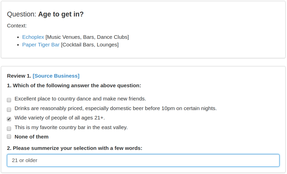
Many services that perform information retrieval for Points of Interest (POI) utilize a Lucene-based setup with spatial filtering. While this type of system is easy to implement it does not make use of semantics but relies on direct word matches between a query and reviews leading to a loss in both precision and recall. To study the challenging task of semantically enriching POIs from unstructured data in order to support open-domain search and question answering (QA), we introduce a new dataset POIReviewQA. It consists of 20k questions (e.g.“is this restaurant dog friendly?”) for 1022 Yelp business types. For each question we sampled 10 reviews, and annotated each sentence in the reviews whether it answers the question and what the corresponding answer is. To test a system’s ability to understand the text we adopt an information retrieval evaluation by ranking all the review sentences for a question based on the likelihood that they answer this question. We build a Lucene-based baseline model, which achieves 77.0% AUC and 48.8% MAP. A sentence embedding-based model achieves 79.2% AUC and 41.8% MAP, indicating that the dataset presents a challenging problem for future research by the GIR community. The result technology can help exploit the thematic content of web documents and social media for characterisation of locations.
Topic:
Question Answering, Information Retrieval, Deep Reinforcement Learning
2017/03 - Present
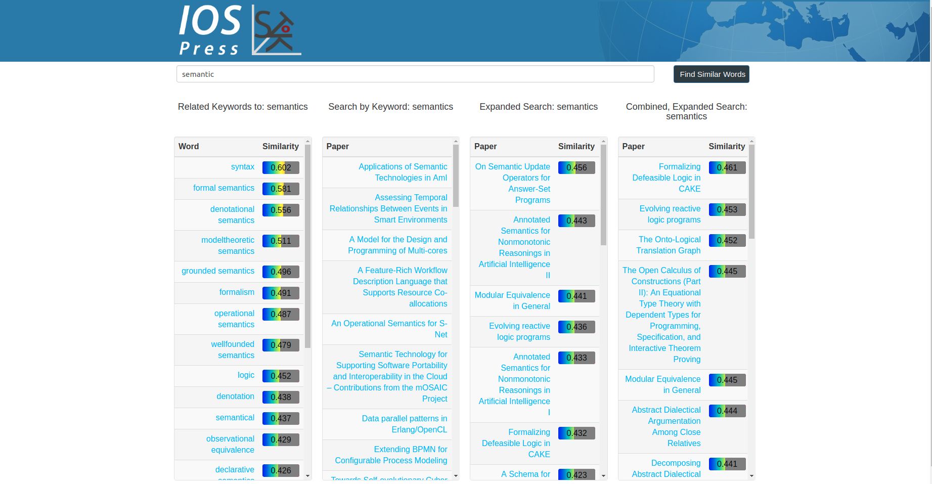
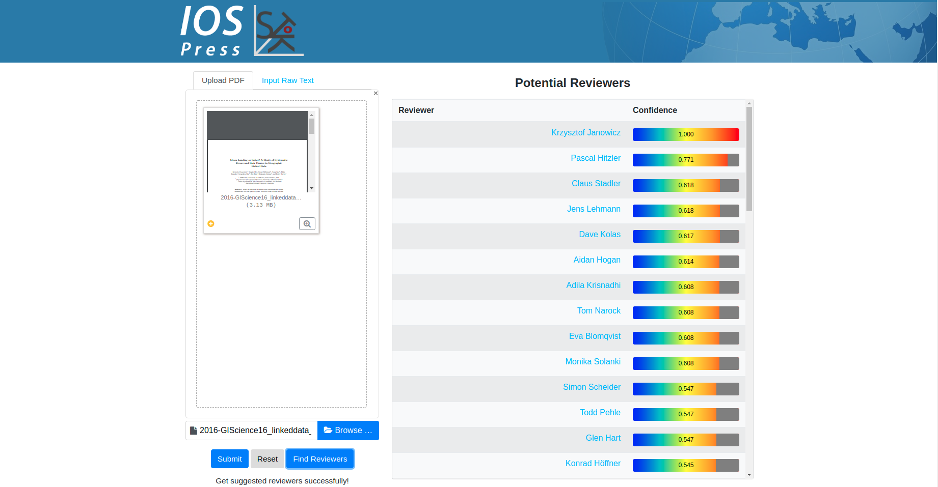
In this work, An academic search engine has been developed on top of IOS LD Connect Knowledge Graph. Document Embedding and Knowledge Graph Embedding have been utilized to facilitate the searching for papers, authors, and reviewers. Note that this search engine has been adopted as the official academic search engine for IOS Press.
2016/10 - Present
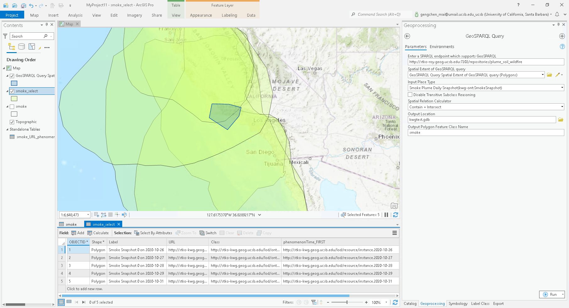
In this work, we conceptualized and prototypically implemented a Linked Data connector framework as a set of toolboxes for Esri’s ArcGIS. We discussed from within a GIS, how to connect to Linked Data endpoints, how to use ontologies to probe data and derive appropriate GIS representations on-the-fly, how to make use of reasoning, how to derive data that is ready for spatial analysis out of RDF triples, and, most importantly, how to utilize the link structure of Linked Data to enable analysis.
GitHub Code Repository:
2016/08 - Present
Funded by IOS Press
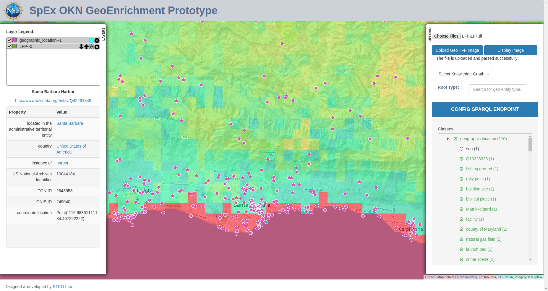
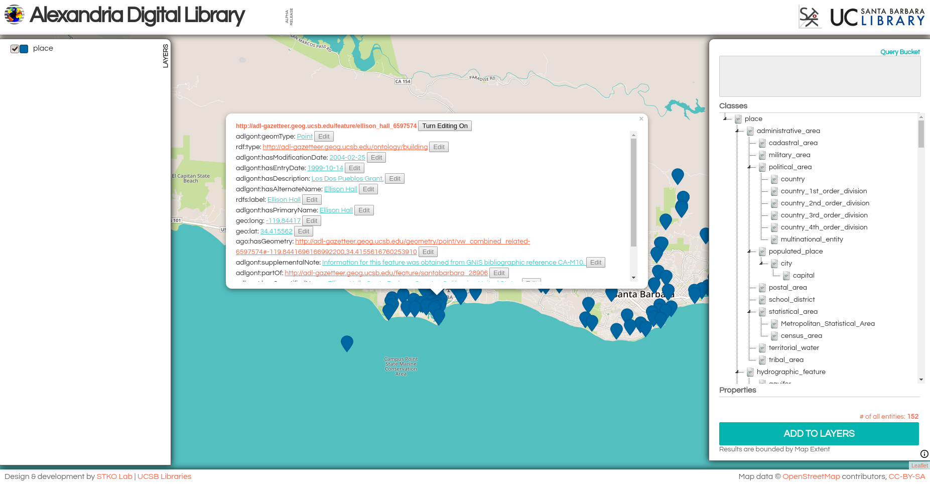
Alexandria Digital Library (ADL) is UC Santa Barbara Library's home for collections of digital research materials. This project aims at leveraging Semantic Web technologies, especially GeoSPARQL, to facilitate the spatial/no-spatial query of ADL Gazetteer and dynamically visualize the results. Right now, the ADL Gazetteer data has been held and managed in a modified version of Apache Marmotta triple store in which GeoSPARQL is enabled. Thanks to all the help from STKO lab members, two different interfaces have been established to facilitate users to interactively explore the geographic data in ADL Gazetteer which are list bellow:
ADL Map Interface:
This is a map interface to help users do spatial/no-spatial queries on ADL Gazetteer, like finding all the entities in "administrative region" class in current map layout whose label contains "paris". GeoSPARQL is used to do spatial queries. Acknowledge to Grant McKenzie and Bo Yan.
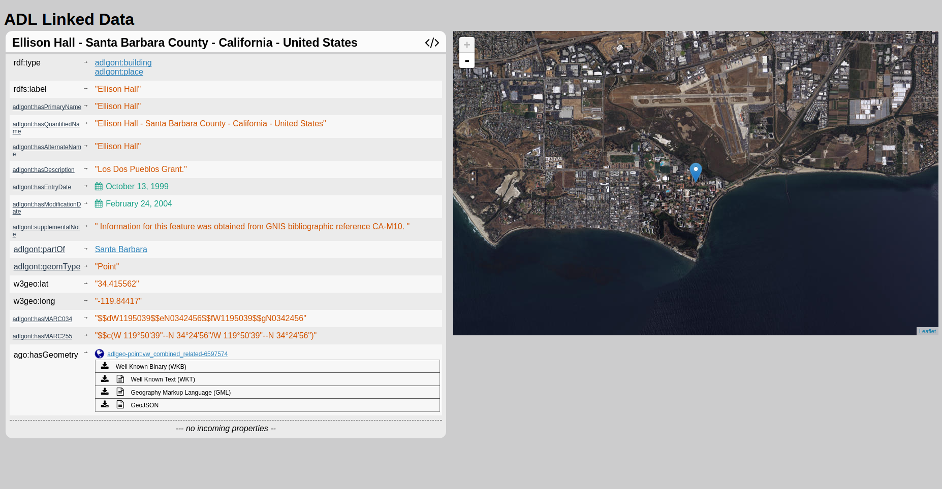
ADL Linked Data Visualizer:
This is a dereferencing user interface for all the entities and entity types in ADL Gazetteer. For example, UC Santa Barbara can be dereferenced by THIS IRI. Acknowledge to Blake Regalia. See more information for our Phuzzy.link paper
.2017/07/16 - 2017/07/18
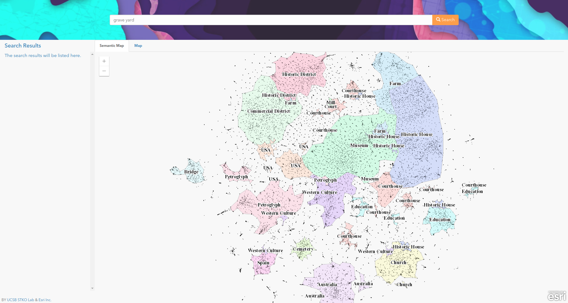
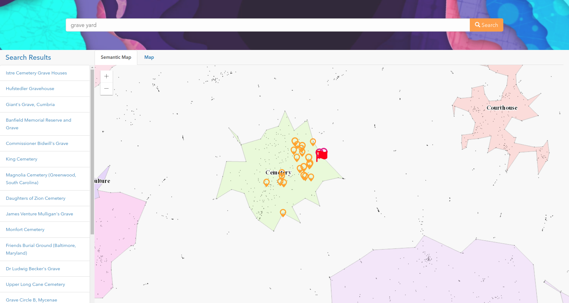
In this work, a semantically enriched geospatial data visualization and searching framework and evaluated it using a subset of places from DBpedia. The resulting map, as a representation of the semantic distribution of these geographic features, is produced by using multiple techniques including paragraph vector and clustering. Next, an information retrieval (IR) model is developed based on the vector embedding of each geographic feature. The results are visualized using the semantic similarity-based map as well as a regular map. We believe such visualization can help users to understand latent relationships between geographic features that may otherwise seem unrelated.
2016/10 - Present
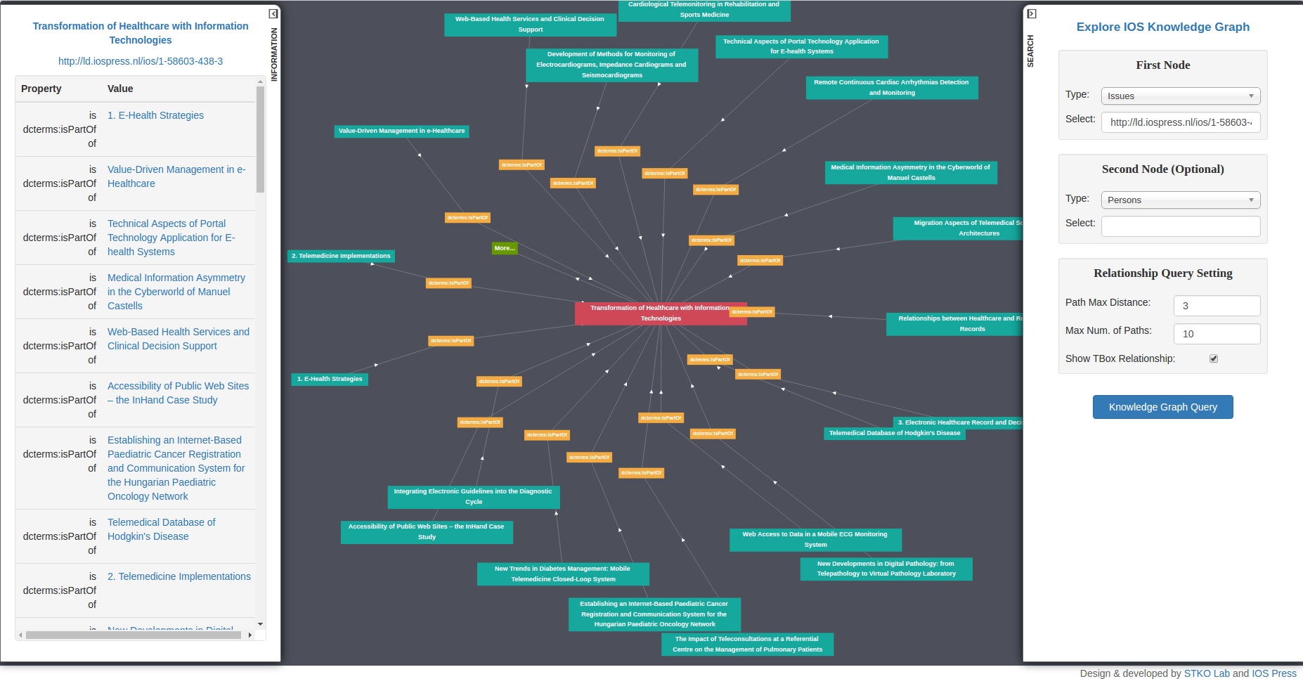
In this work, we developed an Linked Data Visualization Interface for IOS Press Linked Dataset. This interface can visualize the Linked Data Cloud as a graph and users can further explore the graph content using right click menu. The Left sidebar will display the information of the current entity. The irght sidebar helps users do "Relationship Finder" style search.
URL: http://stko-testing.geog.ucsb.edu/gengchen/IOSRelFinder/
2015/09 - 2017/06
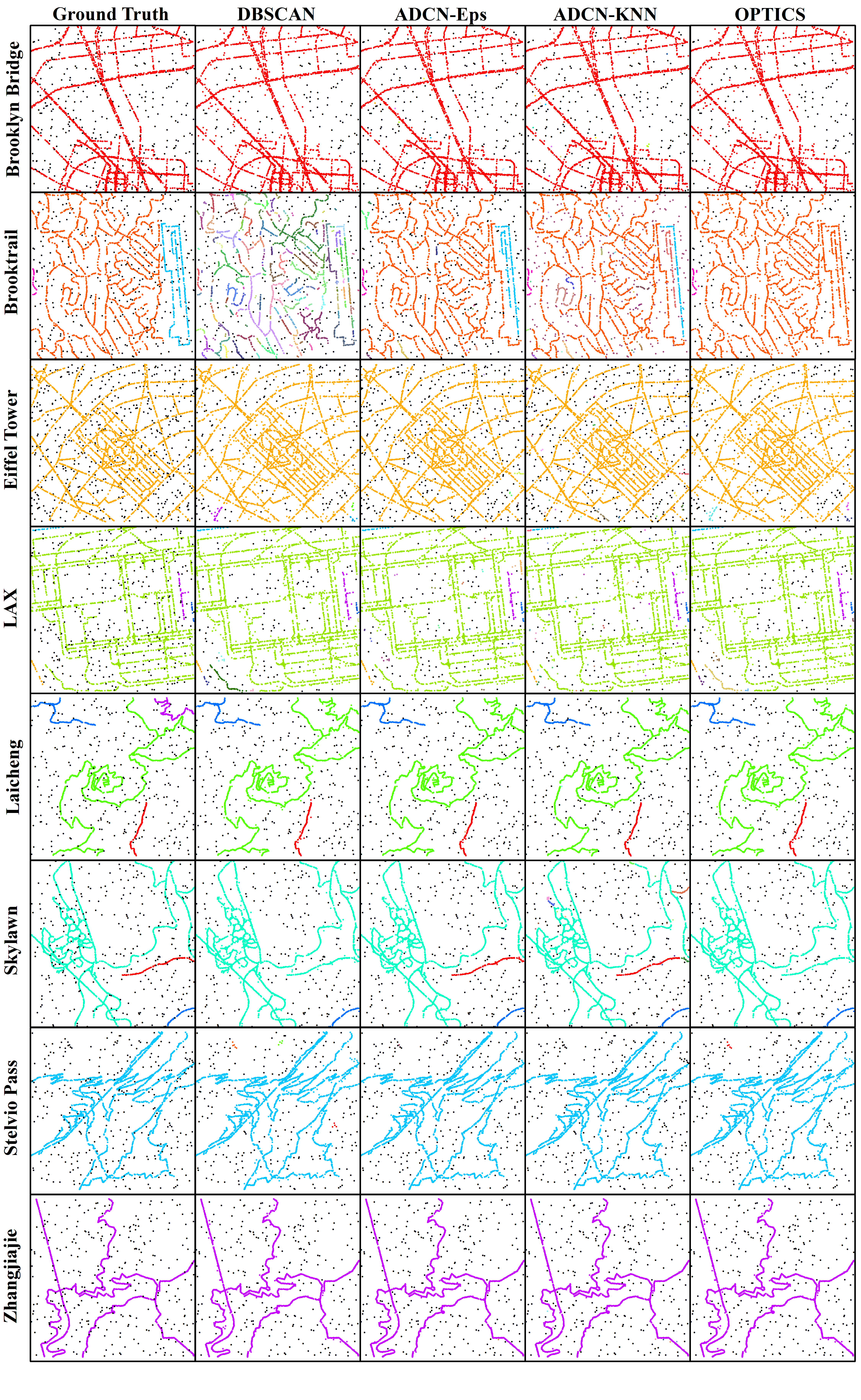
Density-based clustering algorithms such as DBSCAN have been widely used for spatial knowledge discovery as they offer several key advantages compared to other clustering algorithms. They can discover clusters with arbitrary shapes, are robust to noise and do not require prior knowledge (or estimation) of the number of clusters. The idea of using a scan circle centered at each point with a search radius Eps to find at least MinPts points as a criterion for deriving local density is easily understandable and sufficient for exploring isotropic spatial point patterns. However, there are many cases that cannot be adequately captured this way, particularly if they involve linear features or shapes with a continuously changing density such as a spiral. In such cases, DBSCAN tends to either create an increasing number of small clusters or add noise points into large clusters. Therefore, in this paper, we propose a novel anisotropic density-based clustering algorithm (ADCN). To motivate our work, we introduce synthetic and real-world cases that cannot be sufficiently handled by DBSCAN (and OPTICS). We then present our clustering algorithm and test it with a wide range of cases. We demonstrate that our algorithm can perform as equally well as DBSCAN in cases that do not explicitly benefit from an anisotropic perspective and that it outperforms DBSCAN in cases that do. We show that our approach has the same time complexity as DBSCAN and OPTICS, namely O(n log n) when using a spatial index and O(n 2 ) otherwise. We provide an implementation and test the runtime over multiple cases. Finally, we apply DBSCAN, OPTICS, and our ADCN to the extraction of urban Areas of interest (AOI) from geotagged photos in six cities. Visual comparison shows that, comparing to DBSCAN and OPTICS, ADCN is inclined to extract AOI with linear shapes which follow the underline road network. ADCN also turn out to connect areas when the spatial distribution of them shows similar direction.
Data & Platform:
GitHub JS Code Repository:
GitHub Python Code Repository:
2016/01 - 2016/04
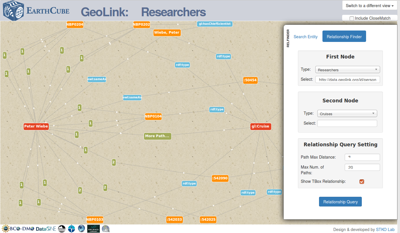
Funded by NSF EarthCube program
GeoLink is a building block project of EarthCube project. It aims at building up a oceanography data integration framwork for seven data repositories and a collections of Ontology Design Patterns. My contribution in this project is creating a graph visualizer to query the paths between two entities. This graph visualizer help the user to discover the data by follow-your-nose search across different data repositories.
2014/01 - 2015/07
Funded by the Fundamental Research Funds for the Central Universities (No. 2042014kf0048)
2014/01 - 2015/12
Funded by Open Research Fund Program of Key Laboratory of Digital Mapping and Land Information Application Engineering, National Administration of Surveying, Mapping and Geoinformation (No. GCWD201404)
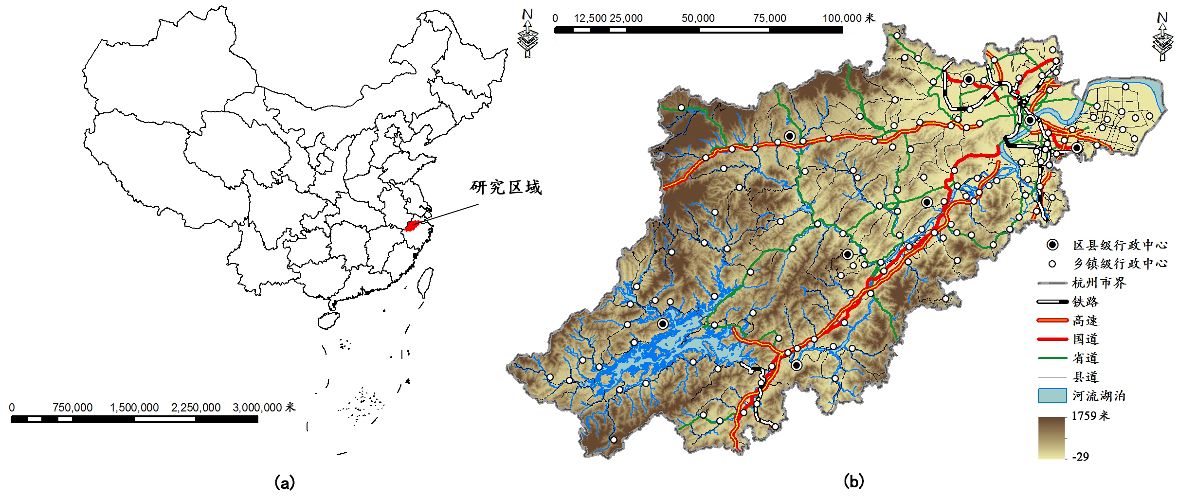
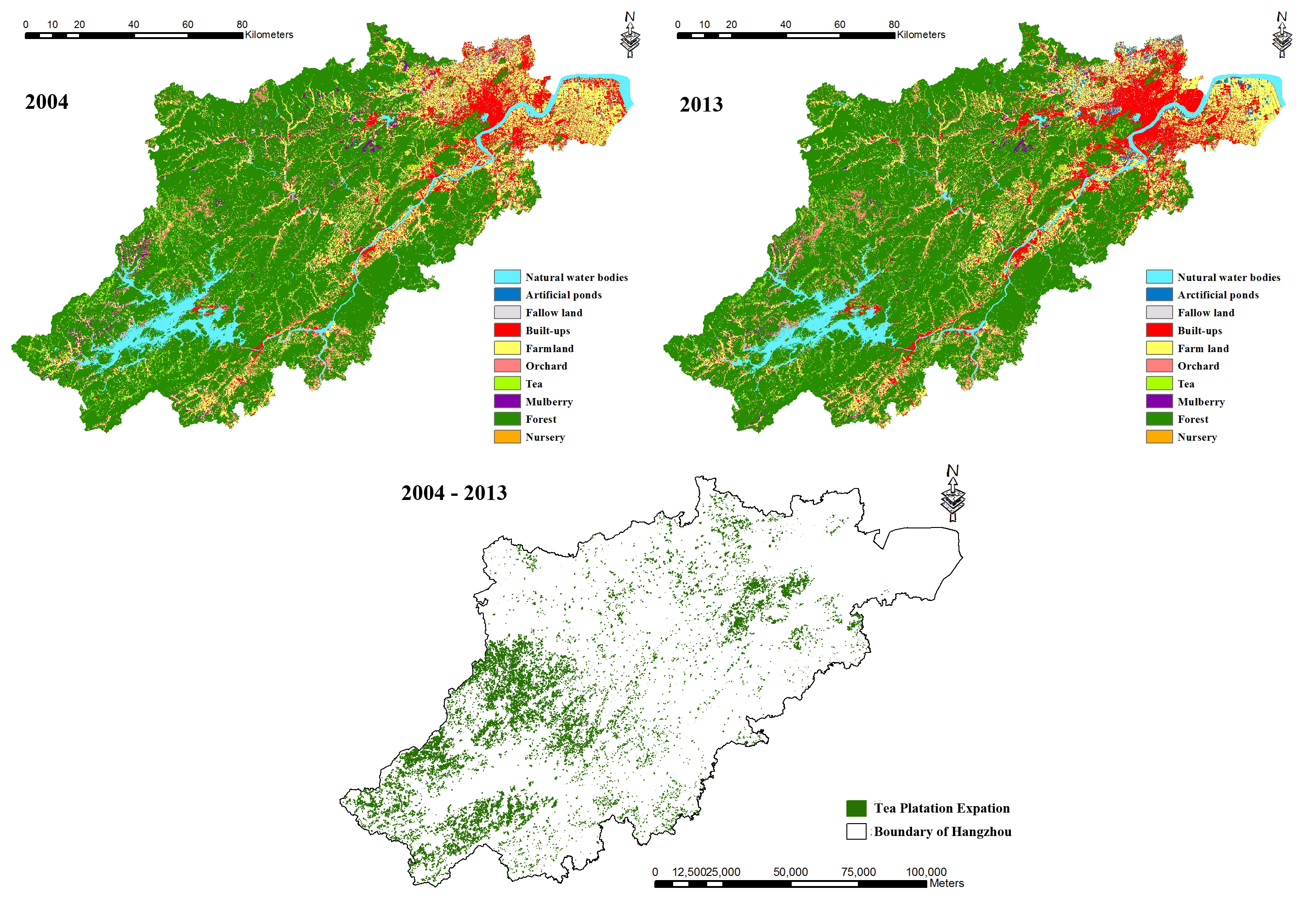
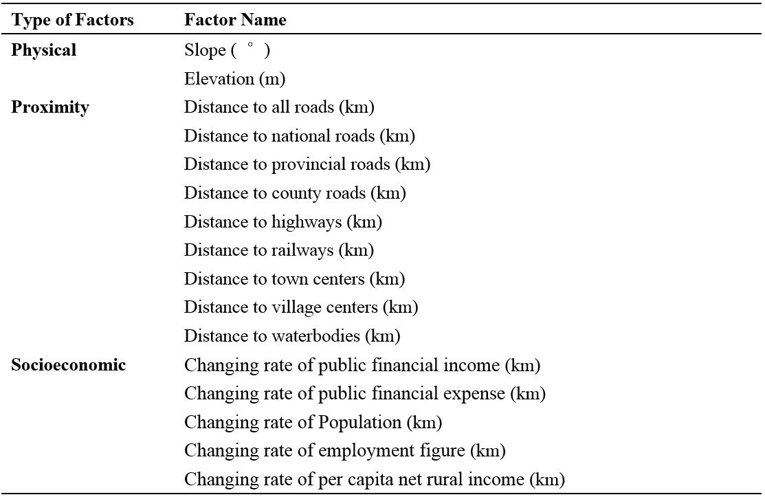
Recently, tea plantation expansion has become a typical land use change in the subtropical zone of China. My experiment integrated remote sensing, spatial analysis deriving from geographic information system, landscape metric analysis and spatial regression, to quantify the socioeconomic indicators of tea plantation expansion and its effects on landscape pattern, with a case of Hangzhou, China, from 2004 to 2013. Main results showed that: (1) Hangzhou has undergone great tea plantation expansion, about 54975.9 ha, from 2004 to 2013. (2) Tea plantation expansion is highly related to some physical, social, and economical factors: slope, elevation, distance to water bodies, distance to roads, distance to socioeconomic centers, public financial revenue and per capita average income of farmers. (4) Tea plantation expansion would make the landscape become fragmentized, complex and irregular. Our study contributed to understanding the socioeconomic indicators of tea plantation expansion and its effects on landscape pattern in subtropical China.
2013/05 - 2015/06
Funded by Planning Project of Innovation and Entrepreneurship Training of National Undergraduate of Wuhan University (No.1310486034)
As a project leader of this undergraduate training project, I developed a C# Application to get check-in data form Sina-blog. And then we evaluated the effect of the construction of Wuhan Subway Line 2 on the spatial distribution of Sina-Blog Check-in data.
URL: Flow Analysis and Research on Subway Based on "Sina micro-blog" Registration data
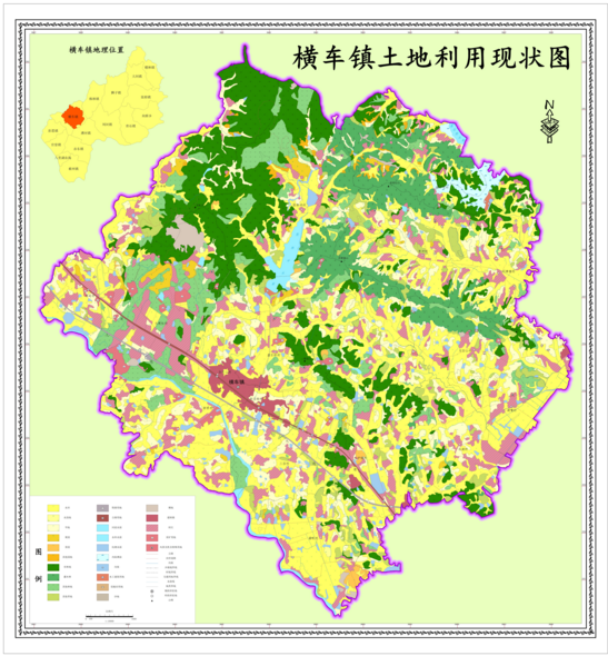
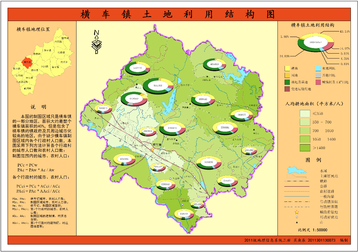
2014/12 - 2015/01
I made two maps of Hengche County by ArcGIS Deasktop. Left one shows the current land use map of Hengche County. The right one shows the Current land use stucture of Hengche County.
Award Number:
Role:
Principal Investigator
Time:
09/01/2025 - 08/31/2028
Member:
Gengchen Mai (PI), Ninghao Liu
Title:
Developing a Smart Electric Vehicle Knowledge Management System with A Cross-Domain Interlinked Electric Vehicle Knowledge Graph
Role:
Principal Investigator
Time:
01/2025 - 12/2025
Member:
Gengchen Mai (PI), Junfeng Jiao
Title:
Map2Loc: Predicting the Georeference of Map Images using Multimodality Foundation Models and Retrieval-Augmented Generation
Role:
Principal Investigator
Time:
01/2025 - 12/2025
Member:
Gengchen Mai (PI)
Title:
A Geospatial Grounded Multimodal Foundation Model
Role:
Principal Investigator
Time:
04/2024 -
Member:
Gengchen Mai (PI)
Title:
A Multimodal Foundation Model for Various Geospatial, Environmental, and Agricultural tasks
Grant:
UGA Presidential Interdisciplinary Seed Grants
Role:
Principal Investigator
Time:
04/2024 - 10/2024
Member:
Gengchen Mai (PI), Tianming Liu, Ninghao Liu, Jin Sun, Xiaobai Yao, Lan Mu, James Marshall Shepherd, Deepak Mishra, Gabriel Kooperman, Anna Harper, Lilong Chai, Guoyu Lu, Adrienne Hoarfrost, Adam Greer
Title:
Cluster Engagement Track: A Geospatial Artificial Intelligence Framework for Accurately Measuring Population Changes of Economically Important Fishes
Grant:
UGA Presidential Interdisciplinary Seed Grants
Role:
CO-PI
Time:
04/2024 - 10/2024
Member:
Adam Greer (PI), Gengchen Mai, Jin Sun
Title:
SSIF: A Deep Generative Model for Remote Sensing Image Spatial-Spectral Super-Resolution for Precision Agriculture
Grant:
Role:
Principle Investigator
Time:
12/2024 - 06/2024
Member:
Gengchen Mai (PI), Tianming Liu, Lilong Chai, Stefano Ermon, Ni Lao, Hongxu Ma, Jinmeng Rao, Jiaming Song
Title:
A one-year Planet license to access high-resolution remote sensing imageries
Grant:
UGA Internal Research Support Co-Funding Program
Role:
Principle Investigator
Time:
2023 - Present
Member:
Gengchen Mai (PI)
Title:
Interdisciplinary Approaches to Alzheimer’s Disease Prevention
Grant:
UGA Interdisciplinary Research Pre-Seed Program
Role:
Co-PI
Time:
2022/12 - Present
Member:
Suhang Song (PI), Zhuo Chen, Kerstin Gerst Emerson, M Mahmud Khan, Janani R Thapa, LISA M Renzi, Tianming Liu, Gengchen Mai, Jin Sun, Angela Yao, Kaixiong Ye
Grant:
UGA Geography Faculty Start-Up Grant
Role:
Principle Investigator
Time:
2022 - Present
Member:
Gengchen Mai (PI)
Title:
A Hybrid Spatially-Explicit Machine Learning Model for Species Spatio-temporal Distribution Modeling and Biodiversity Hotspot Prediction
Role:
Principle Investigator
Time:
2020/06/15 - 2020/09/25
Member:
Gengchen Mai (PI)
Title:
Deep species spatio-temporal distribution modeling for biodiversity hotspot prediction
Grant:
Role:
Principle Investigator
Time:
2019/11 - 2020/11
Member:
Gengchen Mai (PI), Krzysztof Janowicz, Ni Lao, WenyunZuo, Ling Cai.
2025/02/08
2024/11/16
1st place at NARSC 2024 Graduate-Student-Led Paper Competition (Winner –Hao Yang’s coauthor)
2024/09/20
The Best Paper Award at COSIT 2024 for "Probing the Information Theoretical Roots of Spatial Dependence Measures"
2024/04/18
The 1st place at AAG 2024 GISS Student Honors Paper Competition for "Spatial-temporal Explicit Deep Gravity Model (STExDGM) for Origin-Destination Flow Generation" (Nemin Wu's PhD Committee)
2024/04/17
The 1st place at AAG 2024 CISG Robert Raskin Student Paper Competition for " Stable-STICC: Handling Missing, Extreme, and Out-of-Distribution Values in Multivariate Spatial Clustering" (Zhangyu Wang's PhD Committee)
2022/11/04
2022/07/20
Top 10 WGDC 2022 Global Young Scientist Award (10 award recipients every year)
2022/02/26
AAG 2022 William L. Garrison Award for Best Dissertation in Computational Geography (1 award recipients every other year)
2021/12/03
The 1st Best Full Paper Award at ACM K-CAP 2021 (co-author) for "Time in a Box: Advancing Knowledge Graph Completion with Temporal Scopes"
2021/06/11
2021/05/27
The Jack and Laura Dangermond Graduate Fellowship (1 per year)
2021/05/02
Chinese-American Engineers and Scientists Association of Southern California (CESASC) Scholarship
2021/02
AAG Dissertation Research Grants (10 award recipients per year)
2020/06/15 - 2020/09/27
2020/06/15 - 2020/09/27
2020/04/26
2019/11/19 - 2019/11/21
The Jack & Laura Dangermond Travel Scholarship for ACM K-CAP 2019 (1 per year)
2019/11/21
The 1st Place Best Full Paper Award at ACM K-CAP 2019 for "TransGCN: A Translation-Based Graph Convolutional Network Model for Link Prediction" (1 per year)
2019/07/08 - 2019/07/13
The Jack & Laura Dangermond Travel Scholarship for 2019 Esri UC
2019/06/20
The 1st Place Best Full Paper Award at AGILE 2019 for "Relaxing Unanswerable Geographic Questions Using A Spatially Explicit Knowledge Graph Embedding Model" (1 per year)
2019/04/02 - 2019/04/07
The Jack & Laura Dangermond Travel Scholarship for 2019 AAG Annual Meeting
2018/11/12 - 2018/11/16
The Jack & Laura Dangermond Travel Scholarship for EKAW 2018
2018/11/06 - 2018/11/09
The Jack & Laura Dangermond Travel Scholarship for ACM SIGSPATIAL 2018
2018/10/08 - 2018/10/12
NSF Student Travel Awards for ISWC 2018
2018/08/27 - 2018/08/31
ESRI GIScience 2018 Student Travel Awards
2018/08/27 - 2018/08/31
The Jack & Laura Dangermond Travel Scholarship for GIScience 2018
2018/06/12 - 2018/06/15
The Jack & Laura Dangermond Travel Scholarship for AGILE 2018
2018/04/10 - 2018/04/14
The Jack & Laura Dangermond Travel Scholarship for 2018 AAG Annual Meeting
2018/03/01 - 2018/03/02
NSF Student Fellowship for U.S. Semantic Technologies Symposium 2018 (US2TS 2018)
2017/11/07 - 2017/11/10
The Jack & Laura Dangermond Travel Scholarship for ACM SIGSPATIAL 2017
2017/04/06
The 1st Place Best Paper Award at AAG 2017 GIS Special Group Student Paper Competition for "Beyond Coordinates: Incorporating Geographic Knowledge into Geocoding Services Using Linked Open Data" (co-author)
2017/04/05 - 2017/04/09
The Jack & Laura Dangermond Travel Scholarship for 2017 AAG Annual Meeting
2016/10/31 - 2016/11/03
The Jack & Laura Dangermond Travel Scholarship for the 24th ACM SIGSPATIAL International Conference on Advances in Geographic Information Systems (ACM SIGSPATIAL 2016)
2016/09/27 - 2016/09/30
The Jack & Laura Dangermond Travel Scholarship for the 9th International Conference on Geographic Information Science (GIScience 2016)
2016/09/05 - 2016/09/09
NSF Student Fellowship for 12th Reasoning Web Summer School (RW2016)
2016/09/05 - 2016/09/09
The Jack & Laura Dangermond Travel Scholarship for 12th Reasoning Web Summer School (RW2016)
2016/03/29 - 2016/04/02
The Jack & Laura Dangermond Travel Scholarship for 2016 AAG Annual Meeting
2015/09
UCSB Geography Doctoral Scholars Fellowship
2015/06
Outstanding Undergraduate of Wuhan University [武汉大学2015届优秀本科毕业生] (11 out of 8000+ undergraduate students from Wuhan University)
2013/09 - 2014/06
China National Scholarship [国家奖学金]
2013/09 - 2014/06
First-class scholarship and Merit Student of School of Resource and Environmental Sciences, Wuhan University [武大资环院一等奖学金及三好学生]
2012/09 - 2013/06
China National Scholarship [国家奖学金]
2012/09 - 2013/06
First-class scholarship and Merit Student of School of Resource and Environmental Sciences, Wuhan University [武大资环院一等奖学金及三好学生]
2011/09 - 2012/06
China National Scholarship [国家奖学金]
2011/09 - 2012/06
First-class scholarship and Merit Student of School of Resource and Environmental Sciences, Wuhan University [武大资环院一等奖学金及三好学生]
Time
Student
Award
Paper Title
2025/03/25
Zhangyu Wang
2nd place at AAG 2025 GISS Student Honors Paper Competition
LocDiffusion: Identifying Locations on Earth by Diffusing in the Hilbert Space
2024/11/20
Zeping Liu
2nd place at UT 2024 GIS Day Graduate Student Paper Competition
2024/11/20
Qian Cao
1st place at UGA 2024 GIS Day Graduate Student Paper Competition
A Deep Learning Framework on Spatial-social Heterogeneous Graph for Epidemiological Data Mining
2024/11/16
Hao Yang
1st place at NARSC 2024 Graduate-Student-Led Paper Competition
2024/04/18
Nemin Wu
1st place at AAG 2024 GISS Student Honors Paper Competition
Spatial-temporal Explicit Deep Gravity Model (STExDGM) for Origin-Destination Flow Generation
2024/04/17
Zhangyu Wang
1st place at AAG 2024 CISG Robert Raskin Student Paper Competition
2023/11/20
Nemin Wu
1st place at UGA 2023 GIS Day Graduate Student Paper Competition
Spatial-temporal Explicit Deep Gravity Model (STExDGM) for Origin-Destination Flow Generation
Date
Role
Funding Agency
Division
2025/06 -
Proposal Reviewer
Schmidt Sciences Foundation
Early Career Fellowship Program
2024/09 -
Proposal Reviewer
National Science Foundation
Decision, Risk and Management Sciences Program
2022/09 -
Proposal Reviewer
National Science Foundation
Human-Environment and Geographical Sciences (HEGS) Program
Date
Journal
Role
Topic
2023-Ongoing
Lead Guest Editor
SI in Urban Artificial Intelligence Synergy: Fusing Urban Science with Cutting-Edge AI Innovations
2023-2024
International Journal of Geographical Information Science
Lead Guest Editor
SI in GeoFM: Foundation Models for Geospatial Artificial Intelligence
2023-2024
International Journal of Applied Earth Observation and Geoinformation
Lead Guest Editor
SI in Spatially Explicit Machine Learning and Artificial Intelligence
2024-
Spatial Data Science Journal
Editorial Board
2022-2023
Lead Guest Editor
SI in Methods, Models, and Resources for Geospatial Knowledge Graphs and GeoAI
Annals of the American Association of Geographers
International Journal of Geographical Information Science
ISPRS Journal of Photogrammetry and Remote Sensing
International Journal of Applied Earth Observation and Geoinformation
Cartography and Geographic Information Science
Applied Computing and Geosciences
Journal of Transport Geography
Journal of Spatial Information Science
ACM Transactions on Knowledge Discovery from Data
Date
Role
Conference
PC Member:
ICLR 2025, AISTATS 2025, WWW 2025, ICML 2025, GIScience 2025, ACM SIGSPATIAL 2025, ACM MM 2025
Symposium Organizer:
AAG 2025 Symposium on GeoAI and Deep Learning for Geospatial Research
Session Organizer:
Panelist:
AAG 2025 - Generative AI in GIScience: opportunities and challenges towards Autonomous GIS
Workshop Organizer:
ACM SIGSPATIAL 2024 - GeoMachina 2024 workshop
Session Chair:
ACM SIGIR 2024 - Multimedia 1
Symposium Organizer:
AAG 2024 Symposium on GeoAI and Deep Learning for Geospatial Research
Session Organizer:
Session Organizer:
AAG 2024 - Spatially Explicit ML and AI Session I & II & III
Session Organizer:
AAG 2024 - GeoAI for Sustainable and Computational Agriculture I & II
Session Organizer:
AAG 2024 - Advancing health research: Harnessing geospatial big data and geoanalytical techniques
Award Committee:
ACM SIGSPATIAL China Excellent Doctoral Dissertation Award Committee Member 2024
PC Member:
2023
PC Member:
NeurIPS 2023, ESWC 2023, ACM SIGSPATIAL 2023
Event Organizer:
Workshop Organizer:
ACM SIGSPATIAL 2023 - 6th Workshop on AI for Geographic Knowledge Discovery (GeoAI 2023)
Workshop Organizer:
GIScience 2023 - Geospatial Knowledge Graphs and GeoAI Workshop
Workshop Organizer:
GIScience 2023 - Geographic Question-Answering (GeoQA) Workshop
Webinar Organizer:
Session Chair:
2022
Workshop Organizer:
ACM SIGSPATIAL 2022 - 5th Workshop on AI for Geographic Knowledge Discovery (GeoAI 2022)
Workshop Organizer:
ACM SIGSPATIAL 2022 - 1st Workshop on Geospatial Knowledge Graphs (GeoKG 2022)
PC Member:
Workshop Organizer:
GIScience 2021 - Geospatial Knowledge Graphs and GeoAI Workshop
PC Member:
GIScience 2021, ESWC 2021, ISWC 2021, SDSS 2021
2020
PC Member:
ESWC 2020, ISWC 2020
Session Chair:
AAG 2020: GeoAI and Deep Learning Symposium - Geospatial Knowledge Graphs
PC Member:
LDOW-LDDL 2019, ESWC 2019, ISWC 2019, ACM K-CAP 2019
Session Organizer:
AAG 2019: GeoAI and Deep Learning Symposium - Geo-Text Data and Location-based Social Media
2018
Student Organizer:
IOT 2018
2017
PC Member:
ACM K-CAP 2017
Date
Role
Publisher
Book Title
01/2024
Field Editor
Spinger
Encyclopedia of GIS: 2nd Edition
09/2022
CRC Press/Taylor & Francis Group
Book Proposal Reviewer
-
2025/02 - Present
Recognition Committee Member of ACM SIGSPATIAL
2025/10 - 2026/10
Chair of AAG Geographic Information Science and Systems Specialty Group
2025/01 - 2025/12
Registration Co-chair of ACM SIGSPATIAL 2025
2024/11 -
UCGIS Membership Committee Member
2024/10 - 2025/10
Vice Chair of AAG Geographic Information Science and Systems Specialty Group
2024/01 - 2026/01
Non-Student Board of Directors (BOD) Members of Chinese Professional in Geographic Information Systems (CPGIS
2023/08 - 2024/08
Academic Director of AAG Geographic Information Science and Systems Specialty Group
2023/08 - 2024/08
Advisory Committee member of UGA Geography
2022/09 - 2023/06
Technical Faculty Committee Member of UGA Geography
2017/09 - 2018/09
Campus Ambassador of Esri at UCSB
2016/09 - 2017/08
Program Manager of UCSB Cognitive Science
2011/09 - 2013/06
Undersecretary of Department of Life and Welfare in the Students' Union of School of Resource and Environmental Sciences, Wuhan University
Role:
Instructor
Time:
2025 Fall
Institution:
Department:
Teaching Assistant:
Minsoo Joo
Syllabus:
Note:
This class is cross listed with UT Computer Science, and also an elective course for UT Oden Institute CSE Undergraduate Certificate Program.
Role:
Instructor
Time:
2025 Fall
Institution:
Department:
Syllabus:
Class Name:
Role:
Instructor
Time:
2025 Spring
Institution:
Department:
Syllabus:
Role:
Instructor
Time:
2025 Spring
Institution:
Department:
Syllabus:
Role:
Instructor
Time:
2024 Fall
Institution:
Department:
Syllabus:
Role:
Instructor
Time:
2024 Spring
Institution:
Department:
Teaching Assistant:
Arman Oliazadeh
Syllabus:
Class Name:
Role:
Instructor (Co-teach with Dr. Angela Yao)
Time:
2024 Spring
Institution:
Department:
Syllabus:
Role:
Instructor
Time:
2023 Fall
Institution:
Department:
Teaching Assistant:
Syllabus:
Role:
Instructor
Time:
2023 Fall
Institution:
Department:
Teaching Assistant:
Hao Yang
Syllabus:
Role:
Instructor (Co-teach with Prof. Xiaobai (Angela) Yao)
Time:
2023 Spring
Institution:
Department:
Website:
TBD
Role:
Instructor
Time:
2023 Spring
Institution:
Department:
Teaching Assistant:
Syllabus:
Role:
Instructor
Time:
2022 Fall
Institution:
Department:
Teaching Assistant:
Syllabus:
2020 Winter
Guest Lecturer of GEOG 176B: Lecture 9: Analysis, Buffers and Map Algebra
2019 Spring
Guest Lecturer of GEOG 176C: Geographic Question Answering
2018 Spring
Guest Lecturer of GEOG 176C: Geographic Knowledge Graph
2017 Spring
Guest Lecturer of GEOG 176C: GIS Applications: Project Proposal
2017 Winter
Guest Lecturer of GEOG 176B: Lecture 7: Conceptual Modeling and Semantics
Class Name:
Role:
Teaching Assistant
Time:
2016 Spring
Institution:
UC Santa Barbara, Santa Barbara, CA, USA 93106
Department:
Instructor:
Class Name:
Role:
Teaching Assistant
Time:
2016 Summer Session B
Institution:
UC Santa Barbara, Santa Barbara, CA, USA 93106
Department:
Instructor:
Brandi Gamelin
Name
Institute
Role
Time
Placement
UCSB Geography
Ph.D. Dissert. Committee
06/2023 - 03/2025
Tenure-Track AP at Univ. Maine CS
Name
Institute
Role
Time
Placement
UGA Philosophy
AI Master Thesis Committee
08/2023 - 02/2025
PrePostdoc at Harvard Kennedy School
Stanford University; African Institute for Mathematical Sciences
Master Research
08/2021 - 08/2022
Time
Student
Relation
Award
Paper Title
03/25/2025
Zhangyu Wang
PhD Committee Member
2nd place at AAG 2025 GISS Student Honors Paper Competition
LocDiffusion: Identifying Locations on Earth by Diffusing in the Hilbert Space
11/20/2024
Zeping Liu
PhD Advisor
2nd place at UT 2024 GIS Day Graduate Student Paper Competition
China Building rooftop Area: the First multi-annual (2016-2021) and high-resolution (2.5m) building rooftop area dataset in China derived with super-resolution segmentation from Sentinel-2 imagery
11/20/2024
Qian Cao
PhD Co-advisor
1st place at UGA 2024 GIS Day Graduate Student Paper Competition
A Deep Learning Framework on Spatial-social Heterogeneous Graph for Epidemiological Data Mining
04/18/2024
Nemin Wu
PhD Committee Member
1st place at AAG 2024 GISS Student Honors Paper Competition
Spatial-temporal Explicit Deep Gravity Model (STExDGM) for Origin-Destination Flow Generation
04/17/2024
Zhangyu Wang
PhD Committee Member
1st place at AAG 2024 CISG Robert Raskin Student Paper Competition
Stable-STICC: Handling Missing, Extreme, and Out-of-Distribution Values in Multivariate Spatial Clustering
11/20/2023
Nemin Wu
PhD Committee Member
1st place at UGA 2023 GIS Day Graduate Student Paper Competition
Spatial-temporal Explicit Deep Gravity Model (STExDGM) for Origin-Destination Flow Generation
Time
Student
Relation
Position
Company
2025 Summer
Zeping Liu
PhD Advisor
ML Engineering Intern
Esri
2025 Summer
Nemin Wu
PhD Committee Member
AI Resident
Google X
Address:
RLP 3.430, Liberal Arts Building, 305 E 23rd St
Department of Geography and the Environment
University of Texas at Austin
Austin, Texas 78712, USA